3D Printing a slice of the Copernicus DEM
· ☕ 3 min read · ✍️ Alexandru Munteanu
I noticed that the Copernicus DEM (Digital Elevation Model) for both GLO-30 and GLO-90 is available to download freely at opentopography.org. This peaked my interest to see how Timișoara (altough, having a flat terrain) looks like, and to see if it would be possible to do 3D print of it’s Digital Elevation Model. Copernicus DEM: Copernicus DEM at different resolutions. Source: spacedata.copernicus.eu 
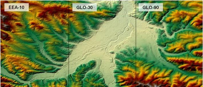
Not only Copernicus DEM is covered on opentopography.org for our AOI:

Romania's cities - an overiew of vegetation using NDVI
· ☕ 2 min read · ✍️ Alexandru Munteanu
Since the recent post, where I only included True Color Imagery using Sentinel-2 data, providing an overview of some major cities, I thought it might also be interesting to extend those examples so we can have a look at the vegetation around (and also inside) of the cities. We can use a simple Normalized Difference Vegetation Index (NDVI) that is computed like so: $$ NDVI = \frac{NIR - RED}{NIR + RED} $$

Romania's Cities - 2017 to present
· ☕ 3 min read · ✍️ Alexandru Munteanu
We propose to showcase the capabilities of the recently created data catalog at the Computer Science department, West University of Timișoara. The catalog exposes Sentinel-2 imagery (currently) using STAC Catalogs. We store Sentinel-2 L1C products from 2017-01-01 till present, covering the whole territory of Romania. This post will illustrate the usage of stackstac in order to turn a STAC Collection into an xarray dataframe that is later processed using dask showing a timelapse of some big cities in Romania throughout the years.

A list of *NIX commands
· ☕ 15 min read · ✍️ Alexandru Munteanu
A plethora of useful CLI commands